
Page 5 - Demo
P. 5
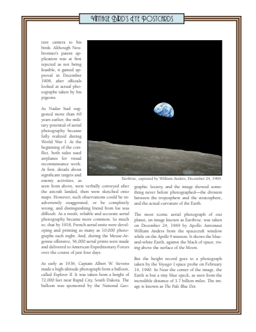
ture camera to his birds. Although Neubronner%u2019s patent application was at first rejected as not being feasible, it gained approval in December 1908, after officials looked at actual photographs taken by his pigeons. As Nadar had suggested more than 60 years earlier, the military potential of aerial photography became fully realized during World War I. At the beginning of the conflict, both sides used airplanes for visual reconnaissance work. At first, details about significant targets and enemy activities, as seen from above, were verbally conveyed after the aircraft landed, then were sketched onto maps. However, such observations could be inadvertently exaggerated, or be completely wrong, and distinguishing friend from foe was difficult. As a result, reliable and accurate aerial photography became more common. So much so, that by 1918, French aerial units were developing and printing as many as 10,000 photographs each night. And, during the Meuse-Argonne offensive, 56,000 aerial prints were made and delivered to American Expeditionary Forces over the course of just four days. As early as 1936, Captain Albert W. Stevens made a high-altitude photograph from a balloon, called Explorer II. It was taken from a height of 72,000 feet near Rapid City, South Dakota. The balloon was sponsored by the National Geographic Society, and the image showed something never before photographed%u2014the division between the troposphere and the stratosphere, and the actual curvature of the Earth. The most iconic aerial photograph of our planet, an image known as Earthrise, was taken on December 24, 1969 by Apollo Astronaut William Anders from the spacecraft window while on the Apollo 9 mission. It shows the blueand-white Earth, against the black of space, rising above the surface of the Moon.But the height record goes to a photograph taken by the Voyager I space probe on February 14, 1990. In Near the center of the image, the Earth is but a tiny blue speck, as seen from the incredible distance of 3.7 billion miles. The image is known as The Pale Blue Dot.Earthrise, captured by William Anders, December 24, 1969.
